

The magic happens before the toxins and pollutants go into the St Louis storm water system.
 |
| Link |
Article 2 Plants as Water Protectors blog series
Article 5- Phytromediation Rafts with ElectrokineticsArticle 4- Plants as Water Protectors
Article 3- Citizen Science Phytoremediation Research StLouis
Article 2- St Louis IKEA Phyto Buffer Zone pt2
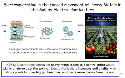
Article 1- IKEAs lesser known environmental project
Plants and the Plant Roots phyto-extract the toxins that washes into the riparian buffer zone from the parking lot of the IKEA store in St Louis.


The following land uses are considered to have a potential for contaminated soil, which may adversely affect the quality of groundwater discharging to surface water. These uses may qualify a project site, or portions of a project site, as a hotspot.
- Sites designated as Comprehensive Environmental Response, Compensation, and Liability Act sites, also known as Superfund Sites,
- Auto recycler facilities and junk yards,
- Commercial laundry and dry cleaning facilities,
- Commercial nurseries,
- Vehicle fueling stations, service and maintenance areas,
- Toxic chemical manufacturing and storage facilities,
- Petroleum storage and refining facilities,
- Public works storage areas,
- Airports and deicing facilities,
- Railroads and rail yards,
- Marinas and ports,
- Heavy manufacturing and power generation facilities,
- Landfills and hazardous waste material disposal facilities, and
- Sites located on subsurface material such as fly ash known to contain mobile heavy metals and toxins.
Suggestion on Designing a Riparian Phytoremediation Buffer Zone for the St Louis Region:
- Rainfall Distribution 50 years of rainfall data for St. Louis, indicates that 90 percent of all rainfall events are 1.14 inches or smaller.
- Communities with large geographic areas may find it beneficial to obtain data from different areas in a community to account for variability in rainfall patterns.
- Rainfall data sets and distributions can be derived from weather service organizations such as the United States Geological Survey (http://mo.water.usgs.gov/) Cumulative Rainfall Distribution for St. Louis, MO,
Next post: How would a Phytoremediation Buffer Zone help Westlake Landfill.


No comments:
Post a Comment