Subscribe To


Tuesday, May 7, 2019
Friday, April 26, 2019
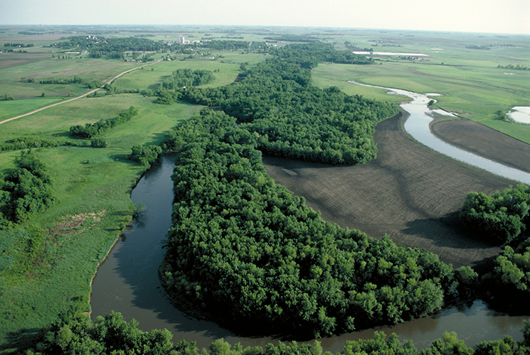
Trees Shrubs as Farm Buffer Zones
Trees and Shrubs growing along the edge of fields act as Farm Buffer Zones and clean farm runoff which protect streams and waterways from toxins and pollutants
RIPARIAN FOREST BUFFERS are trees, shrubs, and grasses located next to rivers, streams, and lakes to help protect aquatic resources by filtering farm runoff and preventing erosion. Buffer areas can support wildlife habitat, produce crops, improve water quality, and reduce flood damage.

Riparian forest buffers are natural or re-established streamside forests made up of tree, shrub, and grass plantings. They buffer non-point source pollution of waterways from adjacent land, reduce bank erosion, protect aquatic environments, enhance wildlife, and increase biodiversity.USDA
Tools
- Conservation Buffers: Design Guidelines for Buffers, Corridors, and Greenways
- Buffer$
- AgBufferBuilder: A Filter Strip Design Tool for GIS
- Riparian Bibliography (Vegetated Stream Riparian Zones: Their Effects on Stream Nutrients, Sediments, and Toxic Substances)
Tuesday, April 16, 2019
Funding Available for Water-Quality Stations that Measure Effectiveness of Conservation Systems on Farms
The USDA’s Natural Resources Conservation Service (NRCS) is making $2 million available to interested farmers to help install voluntary edge-of-field monitoring stations on agricultural land in five states, including Missouri. COLUMBIA, MO, April 16, 2019 –

“Edge-of-field water quality monitoring provides quantifiable data that supports voluntary-based conservation efforts aimed at reducing the movement of sediment and nutrients off Missouri farms,” State Conservationist J.R. Flores said.
Through edge-of-field monitoring, NRCS works with farmers and conservation partners, such as universities and non-governmental organizations, to monitor the amount of nutrients and sediment in water runoff from a field. The data from different conservation systems, and from field with no conservation systems in place, are evaluated to judge effectiveness of the systems. Conservation practices typically evaluated include cover crops, no till, irrigation water management, and practices to reduce and trap nutrients and sediment.
Monitoring stations enable NRCS to measure at the edge of farm fields rather than try to estimate conservation effects from in-stream measurements that are subject to influences outside of the farmer’s control. Edge-of-field monitoring, combined with instream monitoring, can provide a more thorough picture of improvements within a watershed.
NRCS first introduced edge-of-field monitoring in 2011. Since then 19 stations have been in operation in Missouri. Generally, they have shown that conservation practices work best when they are part of an overall system. They also show the importance of having live plants growing during the winter. Flores said the stations have been showing that winter cash crops or cover crops reduce pollutant loading up to 30 percent.
Funding is available on a voluntary basis to farmers in 116 Missouri watersheds. It pays for the costs of installing, maintaining and monitoring the stations for up to nine years. Farmers can check with the NRCS office in their county to see if they are eligible. The results of data collected will be maintained confidentially for farmers’ use and for use by the conservation partners responsible for monitoring.
Farmers interested in applying for financial assistance should submit applications by July 15 to their local NRCS office. To locate an NRCS service center near you, visit the “contact us” section of the website, or look in the telephone directory under, “U.S. Government, Department of Agriculture.”
|
Sunday, April 7, 2019
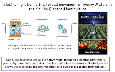
ElectroHemp is on Ideascale looking for Partners
https://mohempenergy.ideascale.com/a/ideas/top/campaigns/16398
__________
Thursday, February 28, 2019
STL Bioremediation and Erosion Control

Those black snake looking net tubes that are used to control erosion are also bioremediation filters.
These images are from the same area of StLouis with the 3 Basin Water Pollution and Filtration setup that cleans pollution from water runoff from a stlouis city street and building parking lots.
Here's some close up images showing how well these dentrifying bioremediation systems work when placed at or near ground level.


The erosion control filters are performing an outstanding job.


 |
| Notice the uphill side in the images above, the soil and organic matter is building up? This proves the filters are trapping the soil runnoff before it travels into the waterway below. |
 |
| Yes those are wood chips in the black snake netting |
This also means any contaminants in the water runnoff are also filtered in this modified dentrifying biofilter.


Sunday, February 17, 2019
StL Plants As Water Protectors
Recently I was in a suburb of StLouis City and happened across this 3 Basin Water Pollution and Filtration setup that cleans pollution from water runoff from a stlouis city street and building parking lots.
A site inspection revealed a 3 level catch basin design. Each catch basin draining into the "downhill" basin below. Each water catch basin also appears to be geared for different contaminant and toxin removal.
Each water basin allows the time needed for the toxins and contaminants the opportunity to mingle and the microbes and plant roots.
This allows the microbes a homebase to feast and break down the contaminants and plant roots the time needed to phytoextract contaminants.
The middle basin with the gravel base is very similar to how a sand filtration system works in a fish tank. The gravel and rocks provide a safe home for the microbes to thrive.
The microbes are the workhorses with this bioremediation system.
Bioremediation and Phytoremediation are the 2 forms of water pollution filtration and cleanup used in this real life St.Louis example. The microbes are the workhorses with this bioremediation system.
 |
| Middle Water Filtration Catch Basin |
 |
| Middle Water Filtration Catch Basin |
 |
| Upper Water Filtration Catch Basin |
 |
| Gravel Base Middle Basin |
 |
| small gravel bioremediation filtration |
Each water basin allows the time needed for the toxins and contaminants the opportunity to mingle and the microbes and plant roots.
This allows the microbes a homebase to feast and break down the contaminants and plant roots the time needed to phytoextract contaminants.
The middle basin with the gravel base is very similar to how a sand filtration system works in a fish tank. The gravel and rocks provide a safe home for the microbes to thrive.
The microbes are the workhorses with this bioremediation system.
Saturday, February 2, 2019
Lessoning Agriculture Field Water Runnoff Pollution
Agriculture contaminants is one of the 3 pollution sources quoted in EWG's Tap Water Database: Pollution Sources and is one reason ElectroHemp has been sharing ways farmers can use buffer zones, filter strips with phytoremediation to lesson field pollution runoff scenarios.
Manure is another important source of water contamination. It’s estimated that livestock produce up to 1 billion tons of manure each year, and runoff from farms and feedlots can be laden with sediments and disease-causing microorganisms. And many pesticides have no federally mandated limits for drinking water, which means utilities and their customers have no benchmark to know if the amount of a specific pesticide in water is safe.
Many water utilities in farm country are forced to treat water supplies to remove agriculture-related pollutants, often relying on expensive processes such as carbon treatment and ion exchange. Despite utilities' efforts, agricultural contaminants are detected in the drinking water served to millions of Americans each year.
Source: EWG's Tap Water Database: Pollution Sources
Agriculture
Agricultural activities are one of the main sources of water pollution for U.S. rivers, streams, lakes, wetlands and groundwater. Each year, farm operators apply more than 12 million tons of nitrogen fertilizer and 8 million tons of phosphorous fertilizer to cropland, some of which runs off into water sources.Manure is another important source of water contamination. It’s estimated that livestock produce up to 1 billion tons of manure each year, and runoff from farms and feedlots can be laden with sediments and disease-causing microorganisms. And many pesticides have no federally mandated limits for drinking water, which means utilities and their customers have no benchmark to know if the amount of a specific pesticide in water is safe.
Many water utilities in farm country are forced to treat water supplies to remove agriculture-related pollutants, often relying on expensive processes such as carbon treatment and ion exchange. Despite utilities' efforts, agricultural contaminants are detected in the drinking water served to millions of Americans each year.
Source: EWG's Tap Water Database: Pollution Sources
Subscribe to:
Posts (Atom)
ElectroHemp Introduction
ElectroHemp Hazardous Waste Remediation Intro
ElectroHemp BioRad Hazardous Waste Cleanup Introduction ElectroHemp - BioRad CleanUp 5 Stage Phytoremediation Treatment Train - Remove...

-
 Too bad the EPA Scientist weren't interested in Solving the Pollution that is contaminating this earth. https://t.co/Kp1JDyrJKq https:/...
 -
Federal Remediation Technology Roundtable Technology Cost and Performance Reports Glass Furnace Technology (GFT) Demonstration at the Hazen ...
-
EPA Takes Important Step to Advance PFAS Strategic Roadmap, Requests Public Input and Data to Inform Potential Future Regulations under CE...